Lesson Suggestions:
1. Knowing how Canada was created is a great starting point for this lesson.
2. Research key-term: Political Boundary
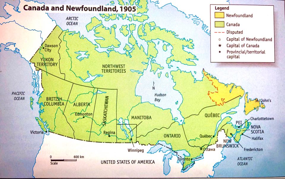
3. Print a Map of Canada showing the provinces such as the map found below. Students can do their own research to find out when each province joined Canada and write the year that it joined over the province. They will be able to visually see each province and the date added above
4. Students can also use the table from the Lesson 1 worksheet and the link from the black box below titled "Historical Boundaries," to check their answers.
5. Read information about cities of Canada.
6. Students can choose 1 or 2 cities, and research what they were like in the early 1900s. Be sure students write a few facts or notes about the cities they have chosen.
7. Complete question from Lesson 1 sheet.
Main concepts:
2. Research key-term: Political Boundary
3. Print a Map of Canada showing the provinces such as the map found below. Students can do their own research to find out when each province joined Canada and write the year that it joined over the province. They will be able to visually see each province and the date added above
4. Students can also use the table from the Lesson 1 worksheet and the link from the black box below titled "Historical Boundaries," to check their answers.
5. Read information about cities of Canada.
6. Students can choose 1 or 2 cities, and research what they were like in the early 1900s. Be sure students write a few facts or notes about the cities they have chosen.
7. Complete question from Lesson 1 sheet.
Main concepts:
- Political boundaries of Canada in the early 1900s.
- What were the 12 largest cities of Canada in the early 1900s and why were these the biggest cities?
For the Student:
Watch this video
If you'd like to read more about Confederation, click here
Activity 1: Historical Boundaries in Canada from Confederation until Early 1900s
At the time of Confederation, the five colonies that united to form Canada in 1867 were Nova Scotia, New Brunswick, Ontario and Quebec.
First Nations and Inuit people had already lived on the land for thousands of years. The colonies did not talk with them about plans for Confederation.
Over the years, other colonies joined Canada with the last being Newfoundland in 1949.
The black box below will take you to a link that will help you fill out the chart for Activity 1.
For this Activity you will find out when the rest of Canada's provinces joined Canada after Confederation.
Cities of Canada
|
In 1911, the twelve largest cities in Canada included Montreal, Toronto, Winnipeg, Vancouver, Ottawa, Hamilton, Quebec City, Halifax, Calgary, Saint John, Edmonton, and Saskatoon.
Many of these port cities grew as they benefitted from the export and/or import of resources at their ports. Some ports are at the ocean, and some are located on rivers or lakes. Other cities grew with the development of resources from the land. Take a look at a few of the cities on google maps below! They are all located close to bodies of water. Toronto is located next to Lake Ontario, Quebec City is located by the Saint Lawrence River, Halifax is located by the North Atlantic Ocean and Winnipeg is located by Red River. |
|
|
Entrepôt: a port, city, or other center to which goods are brought for import and export, and for collection and distribution. Resource: A country's resources are the things that it has and can use to increase its wealth, such as coal, oil, or land. |
|
